Reagan‑era “megaberg” A‑23A — once nearly twice the size of Rhode Island — now on brink of complete disintegration in South Atlantic
The colossal iceberg A‑23A, calved in 1986 and once nearly twice the size of Rhode Island, is now heavily fractured and waterlogged near South Georgia Island in the South Atlantic; scientists say it is likely to disintegrate completely within weeks.
- Long-lived megaberg: A‑23A calved from Antarctica in 1986 and persisted for decades before moving north.
- Rapid decline: Major breakups in 2024–2025 left the remnant heavily waterlogged and shrinking fast.
- High scientific value: Satellite and ISS imagery reveal melt ponds, channels and structural failure that help researchers study iceberg–ocean processes.
- Local relevance: Effects on fisheries, federal research spending and STEM opportunities link the story to places like Redding, California.
Key information
Iceberg name and type: Iceberg A‑23A, a large tabular (flat‑topped) iceberg.
Origin and age: Calved from the Filchner–Ronne Ice Shelf in the Weddell Sea in 1986; also documented on Wikipedia (A23a).
Original and recent size: About 4,000 km² (≈1,544 sq mi) at calving — described as nearly twice the size of Rhode Island — shrinking to roughly 1,182 km² (≈456 sq mi) in early January 2026 after major breakups. Sources: NASA Earth Observatory, Wikipedia, and U.S. National Ice Center.
Location and trend: Now drifting between the eastern tip of South America and South Georgia Island in warmer South Atlantic waters, where scientists say it is “on the verge of complete disintegration.” NASA.
A long life, a dramatic end
A‑23A is notable for its longevity. After calving in 1986 — during Ronald Reagan’s presidency and the year Top Gun was in theaters — the berg ran aground in shallow waters of the southern Weddell Sea and stayed stuck there for more than three decades. It only began moving in 2020, slowly drifting northward. NASA, Wikipedia.
In early 2024 scientists reported A‑23A trapped in a Taylor column, a rotating ocean vortex, over a seamount near the South Orkney Islands. That kept the iceberg rotating in place for months before it escaped and resumed a northward path in the Antarctic Circumpolar Current. By late 2024 and through 2025 the berg moved into the South Atlantic and toward South Georgia, where waters are warmer and melting accelerates. British Antarctic Survey, Wikipedia.
How it is breaking apart
As A‑23A moved into warmer water in mid‑2025, several large pieces calved off in July through September. By September 2025 some reports put the berg at less than half its original area, with battered fragments strewn around it — pieces big enough to threaten ships. Wikipedia.
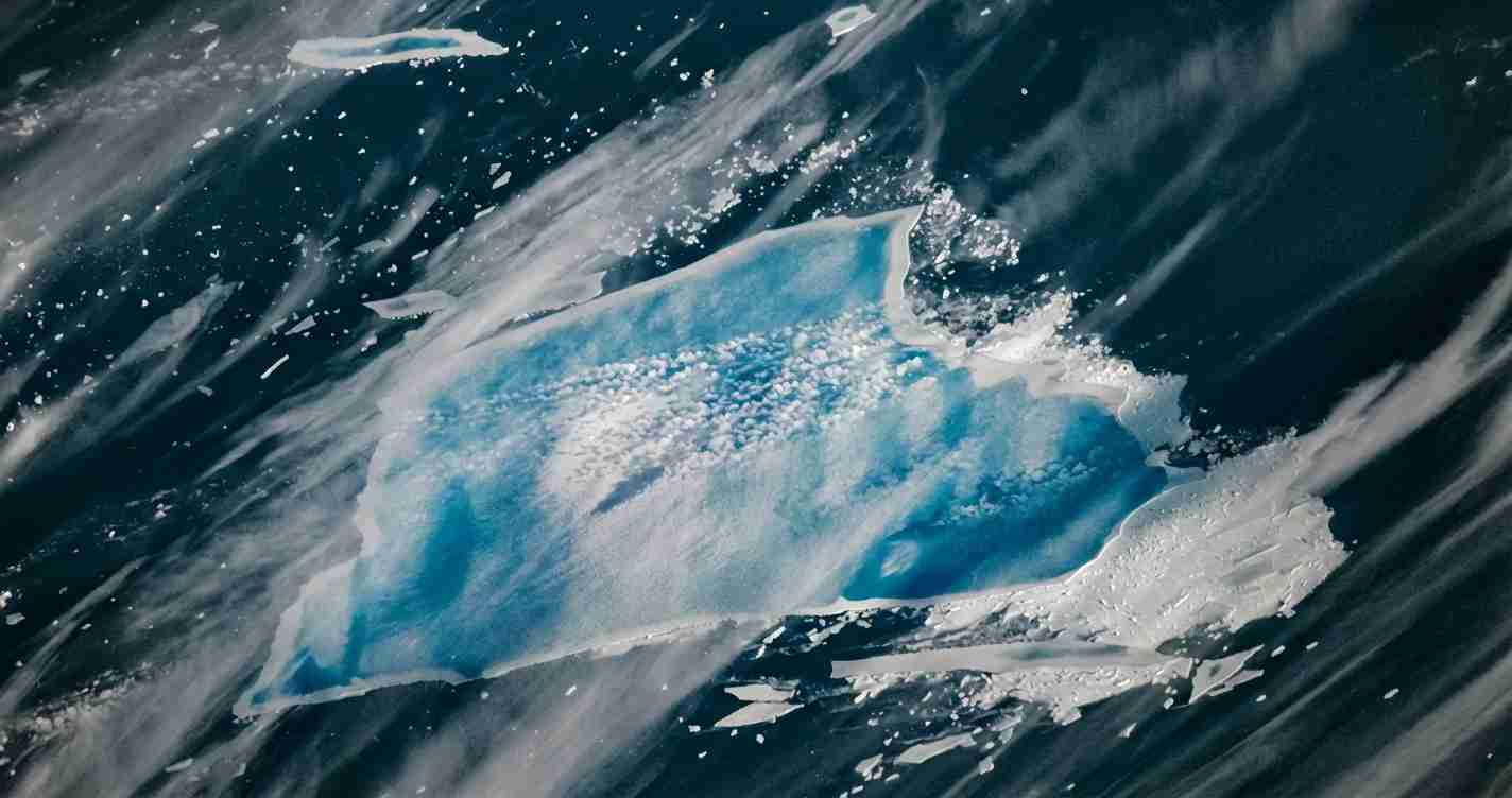
Satellite imagery from late December 2025 shows the berg heavily waterlogged, with bright blue melt ponds, channels, and signs of structural failure. NASA scientists described “blowout” events where pooled meltwater may have punched through the berg’s edge and poured fresh water into the ocean. Those surface ponds and channels — some called “blue mush” by glaciologists — weaken ice by forcing open cracks and accelerating calving. NASA Earth Observatory.
By early January 2026 the U.S. National Ice Center (USNIC) listed the main remnant’s area at 301.77 nautical square miles (data listed 9 January 2026), a rapid reduction reflecting fragments and differing measurement units; NASA summarized the remaining area as about 1,182 km² in early January. Scientists quoted by NASA said A‑23A is likely to disintegrate fully during the current austral summer as it churns in roughly 3 °C water. USNIC, NASA.
What the imagery reveals — and why scientists care
High‑resolution imagery from NASA’s Terra satellite and photographs from the International Space Station in late December 2025 show the berg’s surface in detail. Scientists point to several telling features:
- Bright blue melt ponds and channels: Show extensive surface melting and pooling. These pools make the ice “sopping” wet, increasing the weight and forcing cracks open. NASA.
- Linear blue‑and‑white stripes: Trace ancient bedrock scouring from when the ice was part of a flowing glacier. Those ridges now channel meltwater, shaping disintegration patterns. NASA.
- Rampart–moat patterns: Along edges reveal how melting at the waterline undercuts and reshapes the berg’s perimeter, creating raised rims and lower interior areas that trap meltwater. NASA.
Experts such as Chris Shuman (University of Maryland Baltimore County, retired) and Walt Meier (NSIDC) note these processes make large icebergs vulnerable once they move into warmer ocean and air conditions. NASA.
Ocean setting and the “iceberg graveyard”
A‑23A’s fate is tied to ocean currents and temperature. The Antarctic Circumpolar Current carried the berg north; warmer South Atlantic waters around South Georgia and the tip of South America have long been an “iceberg graveyard” where megabergs tend to break up and melt. Water temperatures of roughly 3 °C in that region greatly speed basal and edge melting. NASA.
A notable oceanographic episode was the berg’s months‑long entrapment in a Taylor column above a seamount — a reminder that undersea topography and circulation can stall or redirect massive ice bodies for years before they move on. EUMETSAT case study, British Antarctic Survey.
Scientific and ecological significance
Researchers view A‑23A as a rare, decades‑long case study of a megaberg’s life cycle. Its long grounding, escape, months trapped in a vortex, and final breakup have offered a clear record for studying iceberg–ocean interactions, sea‑ice dynamics, and ecosystem effects. NASA, BAS.
Large icebergs carry mineral dust and micronutrients, like iron, locked in their ice. As they melt, they can fertilize coastal waters and trigger localized boosts in marine productivity. British Antarctic Survey teams and the RRS Sir David Attenborough collected water samples around A‑23A in December 2023 to study these effects. BAS, Wikipedia.
What scientists say about climate links
Primary reporting and authoritative sources focus on observations and mechanisms of A‑23A’s breakup rather than assigning single‑cause blame. NASA and BAS note that ocean warming, air temperature rises and altered sea‑ice conditions influence how long such bergs survive once they leave Antarctic coastal waters. In short, warmer water strongly controls iceberg decay rates, but the behavior of any single berg reflects many factors — grounding, currents, wind and chance. NASA, BAS.
Sources and further reading
- NASA Earth Observatory: Meltwater turns iceberg A‑23A blue
- Wikipedia: A23a
- British Antarctic Survey: World’s largest iceberg A23A breaks free
- U.S. National Ice Center iceberg products
- EUMETSAT case study: Iceberg A23‑A through the decades
- NOAA/NESDIS tracking summary
Implications for Redding, California
Although Redding sits far from the South Atlantic, the disintegration of Iceberg A‑23A has practical and political implications that can matter to residents, local leaders and conservative audiences focused on stewardship, local jobs and prudent use of public funds.
Economic impact
- Seafood markets and shipping: Large iceberg breakups can alter nutrient flows and coastal productivity, which can ripple through global seafood markets and affect prices for retailers and restaurants serving Redding. BAS.
- Scientific missions and federal spending: Tracking and studying megabergs requires satellites, research ships and government support. Federal investments in ocean monitoring and Antarctic research fund jobs and university projects that can benefit California institutions and contractors — a point often raised by fiscally focused constituencies. NASA.
Political consequences
- Policy debates: The A‑23A story will appear in discussions about ocean warming and national research priorities. Local officials and voters in Redding may use it to press for balanced, cost‑effective policies that protect economic interests without unnecessary regulatory burdens. NASA.
- National security and maritime safety: Drifting ice fragments pose hazards to shipping lanes; agencies tracking A‑23A show federal coordination to protect commerce and navigation — a law‑and‑order, infrastructure‑focused concern for conservative audiences. USNIC.
Social effects
- Community awareness and education: Local schools and colleges can use the A‑23A case to teach earth science, oceanography and practical STEM skills, supporting workforce development and careers in satellite technology and navigation. NASA.
- Public conversation: Dramatic imagery gives neighbors a tangible story to discuss; for conservative audiences this can frame a debate focused on practical adaptation and resilience rather than alarm.
Cultural relevance
A‑23A’s monitored, predictable disintegration illustrates the value of observation, local planning and measured responses over panic — themes that resonate with local values of self‑reliance and stewardship. Preserve data, demand accountability.
Practical applications for local leaders and residents
- Emergency and infrastructure planning: While the berg poses no direct threat to Redding, its study underscores the importance of investing in early warning systems and data‑driven planning for infrastructure and supply chains. Local officials can press for federal data access and partnerships that help Redding plan cost‑effectively. USNIC.
- Education and workforce ties: Community colleges and universities in Northern California could pursue partnerships with federal labs and research programs to train technicians in remote sensing, maritime safety and environmental monitoring — fields that can bring federal grants and private contracts to the region. NASA.
Reporting on A‑23A offers Redding leaders a chance to demand accountable science spending, promote local STEM education, and use clear data to shape sensible, fiscally responsible policy — priorities that align with conservative values while responding to observable changes in the natural world.
“The remaining remnant is heavily fractured and waterlogged; scientists anticipate its complete demise within weeks as it churns in roughly 3 °C South Atlantic water.” — reporting synthesized from NASA, USNIC and BAS sources.