El Niño Could Ignite 2026 Eastern Pacific Hurricane Season — Risks for Northern California
Forecasters warn El Niño could fuel a significantly enhanced 2026 Eastern Pacific hurricane season, increasing the odds of more named storms, hurricanes and rapid intensification — raising coastal and inland risks, including impacts north to Northern California.
- El Niño odds: NOAA-linked summaries and reporting indicate roughly a 61% chance of El Niño developing from May–July 2026, with about a 25% chance of a “super El Niño” by fall — see Time and Fox Weather.
- Active Eastern Pacific expected: Models and regional outlooks are pointing to above-average activity (early forecasts project roughly 18–21 named storms and 9–11 hurricanes) — see the 2026 Pacific hurricane season overview.
- Rapid intensification risk: Eastern Pacific sea surface temperatures are 1–3°C above normal in spots, and deeper warm water increases the potential for surprise rapid strengthening.
- Local implications for Northern California: Redding and Shasta County face both potential benefits (improved water supplies) and hazards (flooding, mudslides, infrastructure stress, higher insurance/cliam impacts).
Mechanism in the Eastern Pacific
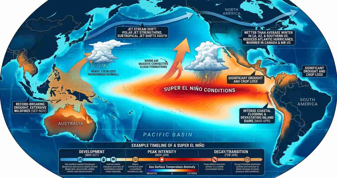
El Niño is a pattern of warmer-than-normal sea surface temperatures across the central and eastern equatorial Pacific. That extra heat alters atmospheric circulation, favoring stronger convection and often lowering local vertical wind shear in the Eastern Pacific — conditions that help storms organize and intensify.
Warm ocean heat content furnishes more energy for tropical cyclones. Current observations show parts of the Eastern Pacific running 1–3°C above normal, and deeper warm layers can fuel episodes of rapid intensification when storms traverse them — a dynamic highlighted in recent briefings and the media analysis from Fox Weather and an expert briefing (osW5wCPwSJM).
“When warm pools deepen, storms can strengthen very rapidly — the same basic physics that produced recent surprise intensifications.”
Why El Niño can ignite the season
- Warm sea surface temperatures: More fuel for convection and stronger storm cores where SSTs are anomalously warm — covered in reporting from Fox Weather.
- Reduced local wind shear: El Niño tends to lower vertical shear in the Eastern Pacific even while raising it over the tropical Atlantic, creating a more favorable environment for organization.
- Rapid intensification potential: Deep warm water layers increase the odds storms will undergo quick spin-ups — a risk underscored by examples like Hurricane Otis (2023).
Timing and forecast outlook
The timing of El Niño matters: an early onset before mid-summer primes the Eastern Pacific for a busy season from the start, while a later build may allow a temporary window for Atlantic activity. NOAA-linked assessments and media summaries put the probability of El Niño emergence from May–July at roughly 61% and a ~25% chance of a strong, or “super,” El Niño by fall — see Time and Fox Weather.
Regional forecasts, including Mexico’s early outlook summarized at the 2026 Pacific hurricane season page, call for an above-average season with 18–21 named storms and 9–11 hurricanes in some projections.
Week-to-week modulation: the MJO
Models also monitor the Madden–Julian Oscillation (MJO), which can concentrate convective bursts and produce episodic clusters of storm formation when it aligns with warm SSTs and low shear — increasing the chance of multiple systems in short order. See expert briefings and videos for operational updates: briefing (osW5wCPwSJM) and briefing (JlHLQ_4U3t8).
Historical patterns
Since 1990, moderate or stronger El Niño years have produced above-average Eastern Pacific seasons roughly 85% of the time. Typical averages in those years gravitate toward about 17 named storms, 9 hurricanes, and 5 major hurricanes — notably above baseline norms, per climatological summaries and expert video analyses.
Where storms go
Most Eastern Pacific hurricanes form off the coast of Mexico and move west or northwest away from the mainland. However, powerful systems can turn toward Baja California or push moisture and dangerous surf northward. Even without a direct landfall, storms can cause heavy surf, coastal erosion and heavy rains in Mexico and, under certain steering patterns, send moisture into California.
Sources and reporting
This article draws on recent media reporting and public model briefings, including Fox Weather’s coverage, a summary of early forecasts at the 2026 Pacific hurricane season page, and detailed analysis of El Niño probabilities in Time. Additional meteorological context is available in public briefings and expert videos: video (osW5wCPwSJM) and video (JlHLQ_4U3t8).
Implications for Redding, California
Local leaders, residents, and businesses should weigh both potential benefits and hazards. A strong El Niño often delivers wetter winters — helpful for reservoirs and groundwater — but can also produce damaging storms, flooding and post-fire slope failures.
Economic impact
- Water and agriculture: Wetter winters can replenish Shasta Lake and local groundwater, benefiting farms and municipal supplies — though storm distribution matters; much of the benefit depends on where precipitation falls.
- Infrastructure and budgets: Flooding, mudslides and road damage can create one-time repair costs and strain county budgets, arguing for targeted preventive spending on levees, drainage and maintenance.
Political consequences
- Preparedness vs. mandates: Debates over who pays for prevention and recovery (city, county, state or federal) may intensify; local projects could become campaign issues.
- Emergency management: The Shasta County Office of Emergency Services and municipal leaders will likely review flood plans, evacuation routes and shelter capacity to minimize reliance on reactive state aid.
Social effects
- Public safety and property risk: Heavy rains can trigger flash floods and mudflows on recent wildfire scars; foothill and canyon communities should be especially vigilant.
- Insurance and housing: Increased flood risk can raise claims and premiums; homeowners should check coverage and document property now.
Cultural relevance
Redding’s culture values self-reliance and practical preparedness. Messaging that emphasizes clear, accountable local planning and simple, actionable steps — securing property, preparing emergency kits and protecting livestock — is likely to resonate.
Practical applications for Redding residents
- Prepare for heavy rain: Clear gutters, secure loose yard items, inspect roofs and trim trees near power lines.
- Know flood routes and shelters: Learn evacuation paths, sign up for county alert systems, and identify community shelter locations.
- Protect wildfire-scarred slopes: Use sandbags and reinforced barriers if you live below burn scars and heed evacuation notices during heavy rain.
- Review insurance: Confirm flood and wind coverage; document property now (photos, receipts) to expedite any future claims.
- Budget and save: Set aside emergency funds for repairs — small preventive investments often avoid larger recovery costs.